
Eyes in the skies
Back in the 1970s, New Zealand’s DSIR was chosen as one of the principal investigators of satellite remote sensing using NASA’s brand-new LANDSAT satellite. Multispectral 60m spatial resolution imagery was recorded on board, downloaded in the USA, processed, and shipped to us for analysis. Sometimes this only took a month or two...
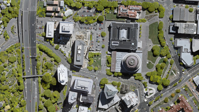
Using precision remote sensing we have mapped every urban tree in Wellington
Scientists now use high resolution, near real-time, state-of-the-art remote-sensing technologies, and smart science to cost-effectively map land cover across the length and breadth of New Zealand. Users of these data and derived information include scientists, government, business, iwi and hapū, universities, schools and the general public in New Zealand and overseas.
Scientists have also pioneered new techniques, harnessing the power of high-speed computing and advances such as LiDAR and AI to enable: cloud clearing from satellite images so they are more usable more of the time; prediction of seed mast years in our native forests by measuring beech flowering – vital information for landowners to plan for seasonal predator control; identification of landslides post-Cyclone Gabrielle; and mapping of trees, including every urban tree in Wellington, pest trees on Rarotonga, and identifying tree species in native forests using high-resolution aerial photography with an incredible 2 cm pixel resolution.
Capturing and using aerial imagery in forest management is another rapidly developing area. Advanced multi-rotor unmanned aerial vehicles (UAVs) are a key tool in research associated with aerial data capture, and a new interactive tool is giving the forestry industry powerful inventory information to make management, harvesting and wood processing decisions easier.